"I want to eat it all" was my initial reaction upon reading through the East Bay Express's "Best of the East Bay 2016: Food and Drink Writers' Picks."
"So how do I do that?" was my second thought. The answer, of course, comes down to planning ahead. My initial impulse was to schedule a series of food runs, but that's the kind of thing that can go off the rails when the rest of your life goes bananas. My next thought: Make it easy to make detours to these best-off places by putting together a map of them. Then, the next time I was out in Oakland or Berkeley and the inevitable "Where do I go eat?" question came up, I could access the map on my mobile phone and see what Food and Drink Writers' Pick was nearby.
Making the map was surprisingly easy and I'll walk you through the process so you, too, can put together maps for good eats or fun hangouts in your area. All told, the process took me 30 minutes, start to finish, and maybe 10 of that was in taking screenshots and checking my work before writing this.
Step One: Make a spreadsheet
Before you even begin your map, format your data. You'll want to make a spreadsheet with two principle columns: the address (or coordinates) of each place you want to tag on your map, and the name of each place. Be sure to make the first row of your spreadsheet the one which labels your columns, like this:

In my spreadsheet, I also included a third column, with the Best-of article's description of the place in question. You can see my Google Sheet here.
Step two: Go to My Maps in Google Maps and click "Create A New Map"
You do have to be logged into your Google account for this step, but just go to https://www.google.com/maps/d/ and you'll see the option to create a new map. See the sample below:

Step three: After you've named your map, import your data set
This part is easy. Each map you make has layers, where you can add different data sets. Name your layer, then click the blue "Import" option immediately below it. See here:

Once you click that link, you have the option of uploading a file (if you made your spreadsheet in Microsoft Excel, for example) or importing it from Google Drive.
When you begin importing, you'll get pop-up windows asking you to match your labeled column to either the place marker or the marker name:

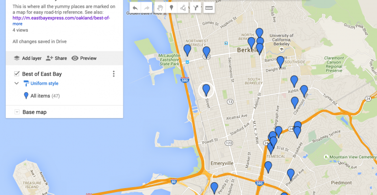
Select your columns, et voila, you have a map with all the places and locations easily marked. You can hover or click to see specific locations:

Now, it's nice that I can look at this map on my computer, but I'm not likely to be toting my laptop with me when I'm out in Berkeley on a Saturday afternoon. So I fired up my Google maps app to see how easy it was to find, load and zoom in on a map I had made.
All I had to do was click the "Your Places" option and scroll down to the maps at the bottom. One more click, and I was able to call up, pinch and zoom on the map to get information about each tagged place:

And now, I'm better prepared to drop in for the best chocolate chip cookie in the East Bay (found at a bagel shop) or nosh on the best hash browns. And because I have the option to change the color of individual tags in the map, I can color-code them depending on whether or not I've visited or want to visit again. (Here's a link to my finished map.)
For as easy as this was, I do have one complaint: When I imported my Google Sheet, the only two columns I could import were coordinates and location name. I'd like to be able to append information to these specific places too. Each of the places I tagged in the Best of the East Bay map had an informative blurb explaining why it was top pick; it would be helpful to have that information associated with each location.
Despite the inability to add helpful, related information to specific map points, I am now thinking of other maps I can make -- one for all the local hiking trails we keep promising to hit on weekends, or perhaps a map for my upcoming rafting-and-hiking trip on Oregon's coast.


